Village Center Mixed-Use Development

The Plan

This development project will contain a mixture of residential and commercial/retail uses on a 2.96-acre site northeast of Eagles Pizza and north of E. Main Street in the Village Center. As proposed, the project will complement and enhance the Village Center by providing a pedestrian-oriented development as envisioned in the Engage New Albany Strategic Plan. By increasing the number of people living and working in the area, the project will support existing and new retail development in the Village Center.

Next Steps

The Architectural Review Board (ARB) approved the Certificate of Appropriateness application for this project during their meeting on February 10, 2025. 

Once engineering and building permits are issued, the developer may begin construction. Construction is planned to start this fall. 

Aerial view of a proposed brick building complex with green rooftops and surrounding streetscape, featuring trees and pedestrian paths.
Proposed brick building with large windows, surrounded by autumn trees and pedestrians on a sidewalk.
Brick building with large windows and signage, tree-lined sidewalk, and blue sky with clouds.

Site Plan

You can view other related documents on the Village Center Mixed-Use Development portion of our Boards and Commissions dashboard by clicking here.

General FAQs

Where is this located?

The 2.96-acre site is generally located northeast of Eagles Pizza and north of E Main Street in the Village Center. The area is shown in red on the map below.

Aerial view of a wooded area surrounded by buildings and parking lots, bordered by streets labeled N High St and E Main St, with a red outline marking a specific section.

Does this project meet the Engage New Albany Strategic Plan goals, objectives and development standards?

Yes. The proposed development is consistent with the recommended development pattern envisioned for the Village Center in the Engage New Albany Strategic Plan. The development accomplishes several strategic plan recommendations including

  • Making New Albany a city where residents can age in place, recognizing the need for housing types that appeal to empty nesters, active seniors, and young professionals:
  • Increases the number of people living and working in the Village Center through new residential and commercial development.
  • Promotes mixed-use and retail infill development to create a continuous and activated street frontage throughout the Village Center.
What are the zoning requirements for the property?

The Urban Center Code applies to the entire Village Center and contains many requirements for development on this property including land use, architecture, parking, and landscaping. The Urban Center Code may be accessed by clicking here.

What impact will the project have on traffic?

The City completed a traffic analysis in the Village Center as part of the Market Street extension project. The proposed development and associated public streets were included in that analysis and do not negatively impact traffic flow in the Village Center. Additionally, the new public streets provide better connectivity in the Village Center to help disburse traffic.

At their February 4 meeting, New Albany City Council approved legislation involving the street network associated with the development project.

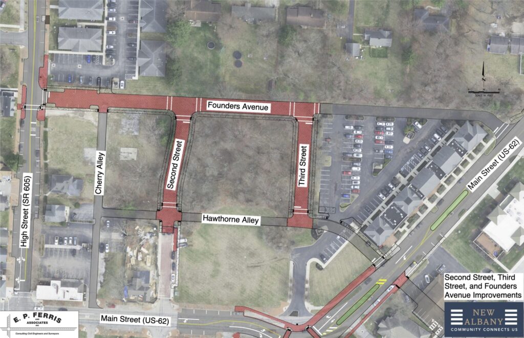
The purpose of this legislation is to adopt a final plat for Second Street, Third Street, Hawthorne Alley, and Founders Avenue. Additionally, the plat vacates 0.0025 acres of public right-of-way for a land swap to connect Founders Avenue to High Street. These proposed right-of-way dedications are identified as a future connection in the Engage New Albany Strategic Plan. The final plat for Second Street, Third Street, Hawthorne Alley, and Founders Avenue consists of approximately 0.933 acres of new right-of-way.

This area north of Main Street between SR 605 and US 62 is disconnected and unorganized. The extension of the street grid and establishment of street connections create a walkable street pattern and blocks for new, Village Center-scaled development. The street dedications and extensions lay the groundwork for additional street grid connections to Miller Avenue. The public street pattern follows the recommendations contained in the Engage New Albany strategic plan and Village Center urban center code.

How will parking be addressed?

The development meets the parking standard found in the Urban Center Code via new off-street parking spaces and existing on street parking in the area. Additionally, new on street parking spaces will be created as part of the project.

What impact will the project have on the schools?

Projects that feature townhomes and apartments have not traditionally had a substantial impact on the New Albany-Plain Local Schools student population. On October 18, 2022, City staff met with the New Albany-Plain Local School District to obtain actual student enrollment numbers for each housing type within the New Albany corporate boundary. The student population numbers are for the 2022-2023 school year. The City staff obtained student population for all flats and townhomes, select single family subdivisions and the total number of students within the city corporate boundary. The number of housing units is from city permitting data. This information is provided in a memo that may be accessed by clicking here.

You can view other related documents on the “New Albany Village Center Mixed-Use Development” portion of our Boards and Commissions dashboard by clicking here.

Contact

If you have any questions about the development project, please contact Sierra Saumenig at ssaumenig@newalbanyohio.org.

City of New Albany
Community Development Department
99 West Main Street, PO Box 188
New Albany, OH 43054